
sITE LISt HOME
Site 1. Knudsen’s Corner
Location: approximately 6200 South and Holladay Boulevard
Date: Beginning in the 1850s
Significance: Canyon “entrance” beginning in the 1850s. In later years, the area housed a grain mill, summer camping retreat, hydroelectric power company, permanent restaurant, gas station, and other businesses. This transformation illustrates the growth and development of Salt Lake City.
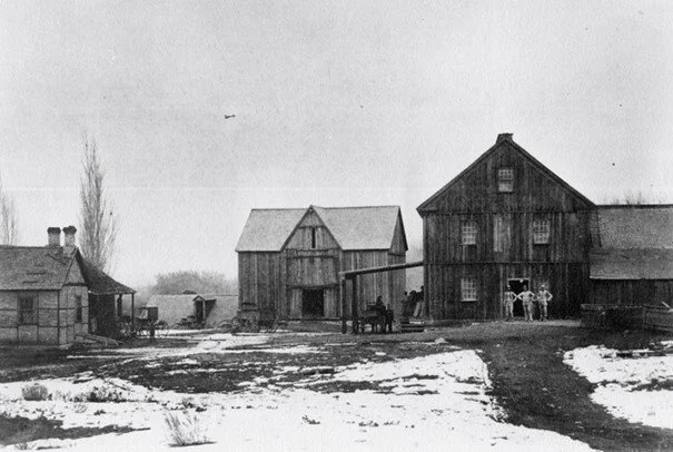
Photo Title: Knudsen’s Flour Mill and surrounding structures [1] Constructed from 1871-1878. (This photo is looking north from the approximate modern-day location of 6200 South and 2715 East. Big Cottonwood Canyon Creek ran to the east of the building on the right.)
Today, the mouth of the canyon begins at Wasatch Boulevard and Big Cottonwood Canyon Road but in the pioneer era of the 1850s, the canyon path began near the present-day intersection of 6200 South and South Holladay Boulevard. Here, you were “in the canyon” with rushing water and dense foliage. At this historic location, the creek intersected two main routes: The north to south path, now named South Holladay Blvd. and the east to west path, 6200 South.[1] When the pioneers began to explore the canyon, their path followed the creek.[2] The crossroads we now call Knudsen’s Corner developed as a “stopover,”[3] halfway between the canyons and the city. Teamsters carting lumber and ore between these destinations would stop here, eventually a small community appeared.
Knudsen’s Corner is named for Rasmussen Knudsen, born in Arlborg, Denmark in 1823, converted to Mormonism, and arrived with his family in the Utah Territory in 1864. Knudsen, a master joiner and millwright, built the most important structure at Knudsen’s Corner; a two-and-a-half -story flour mill.[4] The mill no longer exists but was located on the west side of the creek just north of today’s street address at 2715 East 6200 South. At this address on the north side of the road, you can find the original millstone embedded in a wall made of creek stone.
The businesses at Knudsen’s Corner across the years illustrate the larger progress of Salt Lake City. The 1870s in Utah began a period of vast change, initiated by the 1869 completion of the transcontinental railroad. The Utah territory was now connected with the rest of the country, bringing technology, communication, and economic opportunity. Electricity first came to Utah in 1881, and Knudsen’s Corner housed the Progress Power Company, constructed in 1906, built using concrete from the nearby Sand and Gravel Company founded in 1904.[5] The Knudsen flour mill, powered by the creek, operated from 1878 until 1907, as the growing downtown population required this water.
Utah was admitted to the United States in 1896. According to historian Charles Nickerson, “Statehood in a sense marks the ascendancy of recreation as the dominant activity in the canyon.” [6] Following the grain mill closure, Rudolph Knudsen ran “Knudsen’s Grove” from 1912-1922 on the site of the current Knudsen’s Park. This business venture represented a shift to recreation with transportation infrastructure to support it. At Knudsen’s Grove, this summer retreat allowed city residents to escape the heat for a day or several nights. Platform tents and a seasonal restaurant offered city dwellers “abundant shade, cool, refreshing streams, cozy nooks, shade walks and all the advantages of canyon life – only 12 miles from city and less than 3 miles from present terminus of Holliday Car.” [7]
A permanent restaurant named Knudsen’s Inn opened in 1919 as automobiles were more common. People could drive themselves here for the famous “toasted buttered-bun hamburgers and other toasted sandwiches” [8] to enjoy at the Inn or take up the canyon. A gas station existed here, run by William “Bill” Knudsen and his brother Harvey in the late 1940s-50s, providing services for cars traveling up the canyon. In the mid-1980s, the city’s expansion brought Interstate 215 through the area. The present-day restaurant, Tuscany, occupies the original site of Knudsen’s Inn, and even incorporates some of the Inn’s original stone columns on the 6200 South side. One hundred years later, in 2019, the area that had been Knudsen’s Grove summer retreat became Knudsen’s Park, providing picnic areas with biking and walking paths to follow the pioneer trail towards the canyon.
Interesting Fact: When the Mormon pioneers arrived in 1847, the land was part of the Mexican Territory. The U.S. Congress established the Utah Territory in 1850 and Utah became a State in 1896 making it the 45th state.

Photo Title: Approximate location of historic canyon entrance. The Intersection of 6200 South (Big Cottonwood Road) and South Holladay Blvd. looking southeast towards Tuscany Restaurant, The Cotton Bottom Restaurant and Bar, and the parking lot for Knudsen Park.[10]

Photo Title: Daughters of the Utah Pioneers Marker Number 488, located at 2715 East 6200 South. This plaque commemorates the Knudsen Mill established on this site (north of the fence line) in 1878 and labels the original millstone recovered in 1995 and preserved in the rock wall.[11]

Photo Title: Big Cottonwood Creek at Knudsen’s, 1912. [12] This photo shows a wooden bridge crossing the creek and the dense trees at the creek’s edge. You were considered to be “in the canyon” here.

Photo Title: Home built by Rudolph Knudsen in 1905 in the background. The home sat on the northwest corner of present-day 6200 South and Holladay Blvd, and had electricity. Rudolph crossed this bridge several times a day because his home was on the east side of the creek and his mill was on the west side. [13] This photo was taken approximately between 1905 and 1914. The log bridge was replaced by a scenic cobblestone bridge around 1914.
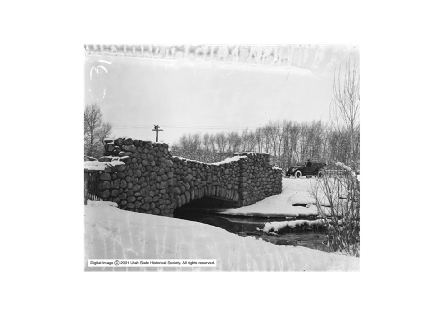
Photo Title: Big Cottonwood Creek, Bridge in Winter 1910-1914. [14] This view is looking southwest. The south parapet of this bridge can be seen today just west of The Cotton Bottom Bar on Big Cottonwood Road. The rest of the bridge was destroyed in the 1983 flood. Around 1913, Salt Lake County recognized the need for scenic drives and invested in canyon roads and bridge improvements, particularly in Parley’s and Big Cottonwood Canyons. This was in response to the nationwide “City Beautiful Movement” emphasizing artistic design in parks, roads and bridges. Salt Lake County held a contest inviting designs from architects rather than engineers or surveyors; the Salt Lake firm of Ware & Treganza designed the bridge at Knudsen’s Corner.[15]
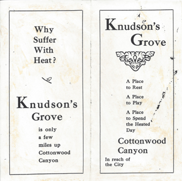

Pamphlet advertising Knudsen’s Grove[16]

Photo Title: Knudsen’s Grove, 1912-1922. From left to right - Pearl Knudsen, the head cook, Annie Knudsen, Deane Knudsen, and an unknown woman holding a triangle. They are posed in front of the screened, open air dining room. [17]

Photo Title: Knudsen Inn, built between 1918-1919, was a restaurant and store providing supplies to campers in Knudsen’s Grove. The little restaurant was known for its hamburgers and ice cream. The Inn sat at the current site of the Tuscany restaurant. This photo was probably taken in the mid-1920s. [18]

Photo Title: William “Bill” Rudolph Knudsen at his gas station on the northeast corner of 6200 South and Holladay Boulevard, photo probably taken in the late 1940s-1950s.[19]
[1] Ottinger, George M. Knudsen Flour Mill. 1900-1925. Photograph. J. Willard Marriott Digital Library, The University of Utah, Salt Lake City. MSS C 297 George M. Ottinger Photograph Collection, https://collections.lib.utah.edu/ark:/87278/s69k85f3. Accessed February 16, 2025.
[2] Roberts, Allen D. City Between the Canyons. Cottonwood Heights, Cottonwood Heights City, 2018, p.180.
[3] Keller, Charles L. The Lady in the Ore Bucket. Salt Lake City, The University of Utah Press, 2001, p. 43.
[4] Roberts, p. 69.
[5] Ibid., p. 152.
[6] Ibid., p.153.
[7] Nickerson, Charles A. Big Cottonwood Canyon and the Century Since Statehood. Big Cottonwood Canyon, Utah, Big Cottonwood Canyon Association, 1996.
[8] Knudsen, Darwin. Reflections – A Providential & Enriching Heritage. Agreka History Publishing (www.historypreserved.com, 1-800-360-5284), 2004, p.13.
[9] Knudsen, p. 16.
[10] Johnson, Max. Historic Canyon Entrance. December 17, 2024. Photograph. Big Cottonwood Canyon Historical Society, Brighton, UT.
[11] Johnson, Max. Knudsen Millstone and Plaque. December 17, 2024. Photograph. Big Cottonwood Canyon Historical Society, Brighton, UT.
[12] Shipler, Harry. Big Cottonwood Canyon, Big Cottonwood Creek at Knudsen’s. 10 May 1912. Photograph. J. Willard Marriott Digital Library, University of Utah, Salt Lake City. Mss C 275; Shipler Commercial Photographers Collection, Shipler #C 28, https://collections.lib.utah.edu/ark:/87278/s6m04gvm. Accessed February 16, 2025.
[13] Photo provided by Karen Knudsen Brown. March 2025.
[14] Shipler, Harry. Big Cottonwood Creek, Bridge in Winter. 1910-1914. Photograph. J. Willard Marriott Digital Library, University of Utah, Salt Lake City. Mss C 275; Shipler Commercial Photographers Collection, Shipler #C31, https://collections.lib.utah.edu/ark:/87278/s67372c4. Accessed February 16, 2025.
[15] “Award Prizes for Bridge Drawings.” The Salt Lake Tribune, May 29, 1913, p. 14.
[16] Knudsen, p. 13.
[17] Photo provided by Karen Knudsen Brown. March 2025.
[18] Photo provided by Karen Knudsen Brown. March 2025.
[19] Photo provided by Karen Knudsen Brown. March 2025.
Learn More:
“Award Prizes for Bridge Drawings.” The Salt Lake Tribune, May 29, 1913, p. 14.
City of Holladay Historic Tour: https://historicholladay.my.canva.site
Daughters of the Utah Pioneers, Application for Plaque
“Gentle Grades Round Granite Hills to Bring Salt Lake to Pine-Clad Canyon Wonderland.” Salt Lake Herald, September 6, 1914, p.13.
Goodman, Jack. “Cozy Cottage at Knudsens’ Corner Stands as Reminder of Bygone Days.” The Salt Lake Tribune, December 21, 1997, D4.
Keller, Charles L. The Lady in the Ore Bucket. Salt Lake City, The University of Utah Press, 2001.
Knudsen, Darwin. Reflections, A Providential & Enriching Heritage. Agreka History Publishing, (1-800-360-5284), www.historypreserved.com, 2004.
Nickerson, Charles A. “Big Cottonwood Canyon and the Century Since Statehood.” Big Cottonwood Canyon, Utah, Big Cottonwood Canyon Association, 1996.
Photos and movie from Doug Wright at the beginning of his radio lecture. His family had a cabin near the site of Knudsen’s Grove: https://www.youtube.com/watch?v=n6iQzUMqUGo&t=3s
“Roads and Bridge in Salt Lake County Are Improved During Year.” Deseret News [Salt Lake City], December 19, 1914, p.38.
Roberts, Allen D. City Between the Canyons, A History of Cottonwood Heights. Cottonwood Heights City, 2018.
“Two Bridges Planned for Big Cottonwood.” Salt Lake Herald, March 10, 1914, p. 5.
“Want Beauty in County Bridges.” The Salt Lake Tribune, May 28, 1913, p.16.
“Will Improve County Roads.” Salt Lake Tribune, March 29, 1913, p.14.
Thanks to Salt Lake architectural historian, David Amott, for sharing newspaper articles on the bridge contest.
Written by Kim Johnson